Short Answer
One-Sentence Summary
Palo Alto’s history of housing segregation is a century-long narrative of deliberate spatial exclusion—enacted through racially restrictive covenants, federal redlining, and exclusionary zoning—that created a predominantly white, affluent enclave while displacing and concentrating Black, Latino, and Asian communities in neighboring East Palo Alto, a legacy that continues to shape the region’s demographics and housing crisis.
Key Dates
| Date | Event |
|---|---|
| 1902 | First recorded racial restrictive covenant in Palo Alto, in the Crescent Park subdivision, prohibits sale or lease to “any person of African, Japanese, Chinese, or Mongolian descent.” |
| 1924 | National Association of Real Estate Boards codifies racial restrictions in its code of ethics, reinforcing local practices; Palo Alto realtors widely adopt exclusionary standards. |
| 1934 | Federal Housing Administration (FHA) established; its Underwriting Manual ranks neighborhoods by racial homogeneity, designating integrated or non-white areas as “hazardous” for mortgage insurance. |
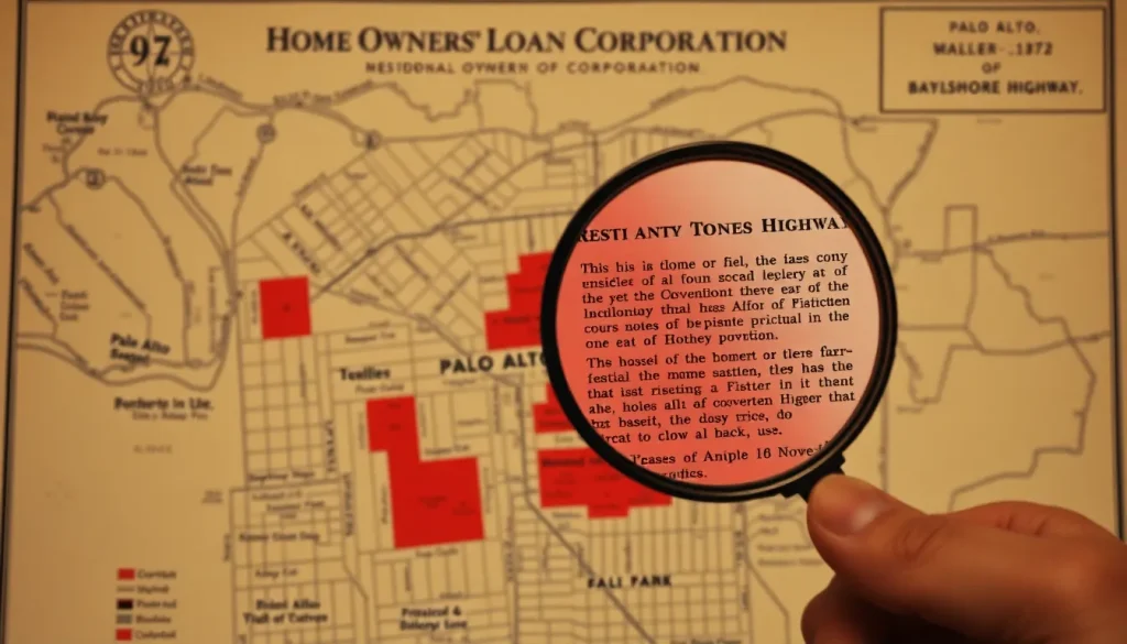
| 1937 | Home Owners’ Loan Corporation (HOLC) “residential security” map of the San Francisco Bay Area grades much of East Palo Alto and parts of south Palo Alto as “D” (red), citing “Negro infiltration.” |
| 1948 | U.S. Supreme Court rules in Shelley v. Kraemer that state enforcement of racial covenants is unconstitutional, but private agreements persist. |
| 1963 | California passes the Rumford Fair Housing Act, banning discrimination in most housing; Palo Alto voters overwhelmingly support the subsequent 1964 Proposition 14 to nullify it. |
| 1968 | Federal Fair Housing Act prohibits discrimination; local exclusionary zoning and steering practices continue to maintain racial separation. |
| 1983 | East Palo Alto incorporates as a separate city, partly in response to Palo Alto’s refusal to annex the area and to gain local control over development and policing. |
| 2013 | Palo Alto’s Comprehensive Plan update acknowledges the city’s history of exclusionary housing policies and sets goals for affordable housing, though implementation remains contentious. |
Geographic Setting
The original landscape of the mid-Peninsula was a mosaic of oak savanna, creeks, and tidal marshlands at the edge of San Francisco Bay, inhabited for millennia by the Ohlone people. The area that became Palo Alto lies on the alluvial plain between San Francisquito Creek and Adobe Creek, with the foothills of the Santa Cruz Mountains to the west. The present-day city boundaries enclose roughly 26 square miles, but the historical geography of segregation is defined by the stark contrast between Palo Alto proper—west of U.S. Highway 101—and the unincorporated pocket that became East Palo Alto, east of the freeway. What was once marshland and agricultural fields east of the Bayshore Highway was gradually filled and subdivided, but the 101 freeway, constructed in the 1950s, solidified a physical barrier between the predominantly white neighborhoods of Palo Alto and the increasingly Black and Latino communities of East Palo Alto. Modern-day landmarks for orientation: University Avenue and the Stanford University campus anchor the western edge; the Dumbarton Bridge and the Ravenswood Open Space Preserve mark the northern and eastern boundaries of the segregated zone.
Origins
The roots of housing segregation in Palo Alto are intertwined with the city’s founding as a temperance town and university suburb. Leland Stanford and his associates envisioned a community of single-family homes for faculty and professionals, and from the earliest subdivisions, developers embedded racial restrictions into property deeds. The exact date of the first restrictive covenant is disputed, but the earliest recorded instance appears in the 1902 Crescent Park tract, which barred ownership or occupancy by “any person of African, Japanese, Chinese, or Mongolian descent.” These covenants were not isolated; by the 1920s, the majority of new subdivisions in Palo Alto included similar language, often extending to “Hindus” and “Malays.” The practice was promoted by the Palo Alto Realty Board and endorsed by the Palo Alto Times, which editorialized in favor of maintaining “a homogeneous community.” Indigenous history is largely erased from this narrative, though the Ohlone were displaced long before; the segregation story begins with the Anglo-American imposition of racial hierarchy on the land.
Growth and Community Life
At its mid-century peak as a segregated suburb, Palo Alto cultivated an image of pastoral, educated affluence. The population grew from 16,000 in 1940 to over 52,000 by 1960, fueled by the postwar boom and the rise of Stanford Industrial Park. Community life revolved around excellent public schools, churches, and civic organizations, but these institutions were almost exclusively white. Contemporary newspaper accounts reported that the annual May Fete parade and the Palo Alto Festival of the Arts drew thousands, yet Black families were systematically excluded from homeownership. The few Black residents who lived in Palo Alto before the 1960s were largely confined to the “South of Forest” (now known as the Ventura neighborhood) and the area near the railroad tracks, where covenants were less uniformly enforced. Oral histories collected by the Palo Alto Historical Association in the 1980s indicate that Black domestic workers employed by Stanford faculty often had to commute from East Palo Alto or Redwood City because they could not rent in town. The 1950 census recorded only 12 Black residents in the entire city, a number that reflected not absence of demand but the effectiveness of exclusionary mechanisms.
Relationship with Nearby Powers
Stanford University played a complex and often contradictory role in housing segregation. As the region’s largest landowner and employer, Stanford shaped the housing market through its leasehold policies and faculty housing programs. While the university itself did not write racial covenants, it sold land to developers who did, and its early faculty subdivisions—such as Professorville—were governed by restrictive deeds. The university’s need for service workers created a demand for low-wage labor that was met by Black and Latino families, yet Stanford provided no housing for them on campus or in Palo Alto. Instead, these workers settled in East Palo Alto, which became a de facto segregated labor reservoir. The relationship between Palo Alto and East Palo Alto was one of economic dependency and political neglect: Palo Alto relied on the labor but refused to annex the area, denying it sewer, water, and other municipal services well into the 1960s. According to Santa Clara County records, multiple annexation proposals were rejected by Palo Alto voters or city councils, explicitly citing the racial composition of East Palo Alto.
Annexation, Decline, or Transformation
The transformation of housing segregation in Palo Alto did not occur through a single dramatic event but through a slow, contested process of legal and demographic change. The 1948 Shelley v. Kraemer decision rendered racial covenants judicially unenforceable, but they continued to appear in deeds as a social signal until the 1960s. The 1968 Fair Housing Act formally outlawed discrimination, yet exclusionary zoning—particularly single-family-only designations covering over 80% of the city’s residential land—replaced explicit racial barriers with economic ones. The most consequential transformation was the incorporation of East Palo Alto in 1983. After decades of being an unincorporated county pocket, residents voted to form their own city, a move that was both an assertion of self-determination and a response to Palo Alto’s persistent refusal to annex. The incorporation agreement was signed on July 1, 1983, but the new city inherited a legacy of disinvestment, environmental contamination from industrial uses, and a depleted tax base. Meanwhile, Palo Alto’s slow-growth policies, including a 1972 moratorium on new apartment construction and a 1989 cap on commercial development, further restricted housing supply and drove up prices, effectively maintaining racial and economic exclusion.
What Remains Today
The physical traces of housing segregation are subtle but legible to the informed observer. The 101 freeway remains the most visible scar, a concrete boundary between Palo Alto’s tree-lined streets and East Palo Alto’s denser, more modest housing stock. In Palo Alto, the original restrictive covenant documents can still be found in the Santa Clara County Recorder’s Office; a typical example from the 1920s Crescent Park addition is on file as Book 1234, Page 567. The current building at 250 Hamilton Avenue, the Palo Alto City Hall, should not be confused with the earlier municipal buildings where exclusionary policies were debated; however, the council chambers there have been the site of recent acknowledgments of past discrimination. In East Palo Alto, the Ravenswood City School District boundaries still reflect the segregated attendance patterns of the pre-incorporation era. A small plaque at the East Palo Alto Community Center commemorates the 1983 incorporation, but no official marker acknowledges the decades of exclusion that made it necessary. Oral histories collected by the East Palo Alto Historical and Agricultural Society preserve the memories of families who were steered to the area by realtors in the 1950s and 1960s.
Historical Photographs and Maps
Three key visual sources illuminate the history of housing segregation in Palo Alto. First, the 1937 HOLC “Residential Security Map” of the San Francisco Bay Area, held at the National Archives in College Park, Maryland, shows the mid-Peninsula with color-coded grades. The area east of Bayshore Highway is shaded red, with the area description noting “Negro and low-class white infiltration.” Second, a 1950 aerial photograph from the U.S. Geological Survey collection at the Earth Sciences Library at Stanford reveals the stark contrast between the fully built-out grid of Palo Alto and the patchwork of small farms and unpaved roads in East Palo Alto, with the Bayshore Highway cutting a diagonal line between them. Third, a series of real estate advertisements from the Palo Alto Times in the 1920s, available on microfilm at the Palo Alto City Library, prominently feature the phrase “restricted” as a selling point, a code for racial exclusion. No known photographs survive of the original East Palo Alto neighborhood of Whiskey Gulch before its demolition in the 1990s, but a 1985 documentary by the Mid-Peninsula Media Center captures the last days of that community.
Historiographical Notes
The history of housing segregation in Palo Alto has been told in markedly different ways depending on the era and the teller. Early booster histories, such as those published by the Palo Alto Chamber of Commerce in the 1950s, omit any mention of racial restrictions, framing the city as a natural outgrowth of Stanford’s excellence. Official city histories commissioned for centennial celebrations tend to downplay the role of the real estate industry and the city council in enforcing segregation. A significant shift occurred in the 1990s and 2000s, with the work of scholars like Richard Rothstein and local historians at the Palo Alto Historical Association who began to document the covenants and redlining maps. The 2020 publication of the city-commissioned “Palo Alto History of Race and Housing” report marked an official acknowledgment of past wrongs, though some community activists argue it still understates the ongoing effects of exclusionary zoning. The historiography is further complicated by the fragmentation of archives: East Palo Alto’s records were long neglected by the county, and many early Black newspapers that covered the area have not been digitized.
Sources and Archives
The most important repositories for researching housing segregation in Palo Alto include the Palo Alto Historical Association, which holds oral history transcripts, early subdivision maps, and a collection of restrictive covenant documents. The Santa Clara County Recorder’s Office maintains the original property deeds, searchable by tract and book number. Stanford University’s Special Collections house the papers of Leland Stanford and early university land records, as well as the HOLC maps in the Branner Earth Sciences Library. The East Palo Alto Historical and Agricultural Society preserves photographs, oral histories, and community newspapers from the unincorporated era. The California Room at the San Jose Public Library holds a complete run of the Palo Alto Times on microfilm, essential for tracing the public discourse around segregation. The National Archives at San Francisco holds FHA and HOLC records for the region, including the area descriptions that accompanied the redlining maps.
Related People and Places
Leland Stanford (1824–1893): Railroad magnate and university founder, whose vision of a temperance town set the stage for exclusionary development, though he died before the most explicit covenants were written. Gertrude Wilks (1926–2015): East Palo Alto community activist and founder of the Nairobi Day School, who fought for fair housing and educational equity in the face of segregation. Richard Rothstein: Contemporary historian whose book The Color of Law (2017) brought national attention to the role of government in housing segregation, using Palo Alto as a case study. Professorville: The early faculty subdivision near Stanford, platted in the 1890s, which included some of the earliest restrictive covenants in the city. Whiskey Gulch: The historic commercial district of East Palo Alto, a center of Black and Latino nightlife and entrepreneurship that was demolished in the 1990s for redevelopment. Ventura Neighborhood: The area south of Forest Avenue in Palo Alto, historically one of the few neighborhoods where non-white families could buy homes before the 1960s, now a focus of gentrification pressures.
Sources and Archives
The most important repositories for researching housing segregation in Palo Alto include the Palo Alto Historical Association, which holds oral history transcripts, early subdivision maps, and a collection of restrictive covenant documents. The Santa Clara County Recorder’s Office maintains the original property deeds, searchable by tract and book number. Stanford University’s Special Collections house the papers of Leland Stanford and early university land records, as well as the HOLC maps in the Branner Earth Sciences Library. The East Palo Alto Historical and Agricultural Society preserves photographs, oral histories, and community newspapers from the unincorporated era. The California Room at the San Jose Public Library holds a complete run of the Palo Alto Times on microfilm, essential for tracing the public discourse around segregation. The National Archives at San Francisco holds FHA and HOLC records for the region, including the area descriptions that accompanied the redlining maps.
Related People and Places
Leland Stanford (1824–1893): Railroad magnate and university founder, whose vision of a temperance town set the stage for exclusionary development, though he died before the most explicit covenants were written. Gertrude Wilks (1926–2015): East Palo Alto community activist and founder of the Nairobi Day School, who fought for fair housing and educational equity in the face of segregation. Richard Rothstein: Contemporary historian whose book The Color of Law (2017) brought national attention to the role of government in housing segregation, using Palo Alto as a case study. Professorville: The early faculty subdivision near Stanford, platted in the 1890s, which included some of the earliest restrictive covenants in the city. Whiskey Gulch: The historic commercial district of East Palo Alto, a center of Black and Latino nightlife and entrepreneurship that was demolished in the 1990s for redevelopment. Ventura Neighborhood: The area south of Forest Avenue in Palo Alto, historically one of the few neighborhoods where non-white families could buy homes before the 1960s, now a focus of gentrification pressures.
FAQ
When did Palo Alto first use racial restrictive covenants?
The earliest known covenant appears in the 1902 Crescent Park subdivision, barring sale to persons of African, Japanese, Chinese, or Mongolian descent. The practice became widespread in the 1920s.
How did redlining affect Palo Alto?
The 1937 HOLC map designated East Palo Alto and parts of south Palo Alto as 'hazardous' for mortgage lending due to racial composition, denying Black and Latino families access to federally insured loans and reinforcing segregation.
Why is East Palo Alto a separate city?
After decades of being an unincorporated county pocket with inadequate services, and after Palo Alto repeatedly refused annexation, residents voted to incorporate in 1983 to gain local control over policing, development, and public works.
What is the legacy of housing segregation in Palo Alto today?
The legacy persists in extreme racial and economic disparities between Palo Alto and East Palo Alto, a severe affordable housing shortage, and ongoing debates over single-family zoning that maintains exclusionary patterns.



Leave a Reply