
Short Answer
Location
El Palo Alto stands on the east bank of San Francisquito Creek, within the small triangular El Palo Alto Park at the intersection of Alma Street and Palo Alto Avenue in Palo Alto, California. The tree marks the historic boundary between Santa Clara and San Mateo counties, and its roots are anchored just feet from the Caltrain railroad tracks that trace the route of the original Southern Pacific line. The park is a modest 0.6-acre green space, but the tree’s towering presence—visible from the Alma Street overpass and the adjacent bike path—makes it an unmistakable landmark. Its precise coordinates are 37°26′42″N 122°10′12″W, placing it at the northern gateway to the city that borrowed its name.
Why It Is Significant
El Palo Alto is far more than an ancient tree; it is the living root of a city’s identity and a witness to over a millennium of human history. The coast redwood (Sequoia sempervirens) was already centuries old when the Ohlone people fished San Francisquito Creek in its shade. In November 1769, the Portolá expedition—the first Spanish overland journey through Alta California—camped beside the towering double-trunked tree and recorded it as El Palo Alto, “the tall tree.” That name, scrawled in a friar’s diary, would eventually be adopted by the city of Palo Alto, incorporated in 1894. Today, the tree is California Historical Landmark #2, a designation that underscores its foundational role in the state’s recorded history. It is also a potent symbol of resilience: having survived centuries of natural and human-induced change, including the loss of one of its twin trunks in a 19th-century storm, the tree remains a living link between the indigenous past, the Spanish colonial era, and the rise of Silicon Valley.
Historical Timeline
| Date | Event |
|---|---|
| c. 940 CE | Coast redwood seedling germinates on the banks of San Francisquito Creek, eventually growing into a twin-trunked giant. |
| Pre-1769 | The tree is a known landmark for the Ohlone people, who inhabit the region for thousands of years. |
| November 6–10, 1769 | The Gaspar de Portolá expedition camps near the tree. Franciscan friar Juan Crespí names it El Palo Alto in his diary. |
| 1776 | Juan Bautista de Anza’s expedition passes the tree, further cementing its role as a waypoint on El Camino Real. |
| 1850s | American settlers arrive; the tree becomes a landmark for stagecoach routes and surveying the boundary between San Mateo and Santa Clara counties. |
| c. 1886 | A violent winter storm shears off one of the twin trunks, leaving the surviving trunk with a massive scar. |
| 1894 | The city of Palo Alto is incorporated, taking its name directly from the historic tree. |
| 1951 | El Palo Alto is designated California Historical Landmark #2. |
| 1960s | Construction of the Alma Street overpass and railroad encroachment threaten the tree’s root system. |
| 1999 | Major preservation project: soil aeration, root invigoration, and installation of a permanent irrigation system. |
| 2004 | A lightning strike damages the crown; subsequent cabling and bracing stabilize the tree. |
| 2015–present | Ongoing arboricultural monitoring, including annual health assessments and soil management. |
Architectural or Natural Characteristics
Physical Dimensions and Form
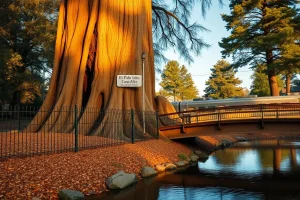
El Palo Alto is a coast redwood (Sequoia sempervirens), a species renowned for its longevity and towering height. The surviving trunk rises approximately 110 feet (33.5 meters) with a diameter at breast height of about 90 inches (2.3 meters). The crown, though reduced by lightning and age, still spreads roughly 60 feet (18 meters) wide. The bark is thick, fibrous, and deeply furrowed, a characteristic reddish-brown that glows warmly in afternoon light. A prominent vertical scar on the north side marks where the second trunk once grew; that trunk, nearly equal in size, was torn away by a winter storm in the mid-1880s, leaving the remaining tree permanently lopsided.
Species and Ecology
Coast redwoods are the tallest tree species on Earth, but El Palo Alto’s stature is modest compared to its old-growth cousins in the Santa Cruz Mountains. Its location at the dry, inland edge of the redwood’s range—just 5 miles from San Francisco Bay—means it endures hotter summers and less fog moisture than coastal groves. The tree survives thanks to a deep taproot that reaches the water table of San Francisquito Creek and an extensive lateral root system. Its needles are short, flat, and arranged in sprays, typical of the species, and it produces small, woody cones. Despite its age, the tree continues to generate new growth each spring, a testament to the resilience encoded in redwood DNA.
Cultural Meaning
Indigenous Heritage
Long before Spanish chroniclers set eyes on the tree, the Ohlone people knew this landmark intimately. The Puichon tribelet of the Ohlone inhabited the area around San Francisquito Creek, and the massive twin redwood likely served as a gathering place, a navigational marker, and a spiritual symbol. While no written records survive, oral traditions and archaeological evidence confirm that the Ohlone managed the landscape with controlled burns and selective harvesting, practices that would have influenced the tree’s immediate environment.
Spanish Colonial Legacy
The name El Palo Alto first appears in the diary of Franciscan friar Juan Crespí, who accompanied the Portolá expedition in 1769. Crespí wrote of “a very tall tree, double-trunked, which we named El Palo Alto.” The tree became a critical waypoint on El Camino Real, the royal road connecting California’s missions. For later Mexican rancheros and American settlers, the tree marked the boundary between the vast Rancho San Francisquito and Rancho Rinconada del Arroyo de San Francisquito.
Modern Symbolism
When the city of Palo Alto incorporated in 1894, it deliberately adopted the tree’s name, embedding the natural landmark into its civic identity. Today, El Palo Alto appears on the city seal, and its stylized image graces street signs, public art, and the logo of Stanford University’s athletic teams (the “Stanford Tree” is an unofficial mascot inspired by the redwood). The tree has become a symbol of endurance and rootedness in a region defined by rapid technological change—a living counterpoint to the ephemeral nature of Silicon Valley startups.
“This tree has watched the centuries pass like hours. It is the oldest citizen of Palo Alto, and perhaps the wisest.” — Ward Winslow, Palo Alto: A Centennial History
Visiting Information
Getting There
El Palo Alto Park is located at 117 Palo Alto Avenue, Palo Alto, CA 94301. The site is easily accessible by car, bicycle, or public transit. The park sits directly adjacent to the Palo Alto Caltrain station (a 5-minute walk via the Alma Street underpass). SamTrans bus routes 280 and 281 stop nearby on University Avenue. For cyclists, the bike path along Alma Street leads directly to the park, and bike racks are available.
Hours and Fees
- Park hours: Open daily from dawn to dusk.
- Admission: Free.
- Parking: Limited free street parking on Palo Alto Avenue and adjacent side streets; observe posted restrictions.
Facilities
The park is a small, passive green space with no restrooms, water fountains, or picnic areas. A paved path leads to a viewing platform and interpretive signage. Benches offer a place to sit and contemplate the tree. The nearest public restrooms are at the Palo Alto Caltrain station or nearby Peers Park.
Best Time to Visit
Early morning or late afternoon provides the most dramatic light for photography, with the low sun illuminating the redwood’s textured bark. Spring brings fresh green growth to the crown, while autumn offers mild temperatures and fewer crowds. The tree is particularly atmospheric on foggy mornings, when mist clings to its needles.
Accessibility
The park features a level, paved pathway from the street to the viewing area, making it wheelchair accessible. The interpretive panel is mounted at a readable height. However, the immediate area around the tree’s base is mulched and uneven; visitors with mobility devices can view the tree clearly from the paved platform. Accessible parking spaces are not designated, but the street parking is generally flat. Service animals are welcome.
Preservation Status
Conservation Efforts
El Palo Alto is protected as California Historical Landmark #2 and is listed on the Palo Alto Historic Inventory. The City of Palo Alto’s Urban Forestry division, in partnership with certified arborists, conducts annual health assessments. A permanent irrigation system, installed in 1999, delivers water to the root zone during dry months. The tree is surrounded by a protective fence to prevent soil compaction from foot traffic. In 2004, after a lightning strike, a steel cable and brace system was installed to support the weakened crown. Soil aeration and organic mulching are performed regularly to mimic the forest floor conditions the tree evolved in.
Challenges and Threats
The tree faces ongoing stress from its urban environment: air pollution, vibration from passing trains, and restricted root space due to adjacent pavement and the Alma Street overpass. Climate change poses a long-term threat, as reduced coastal fog and hotter summers push the species beyond its comfort zone. Invasive ivy and other plants are periodically removed. Despite these pressures, the tree has shown remarkable resilience, with arborists reporting stable canopy density and new growth in recent years.
Common Misconceptions
Misconception: It Is a Giant Sequoia
Many visitors assume El Palo Alto is a giant sequoia (Sequoiadendron giganteum), the massive trees of the Sierra Nevada. In fact, it is a coast redwood (Sequoia sempervirens), a distinct species that grows taller but less massive. Coast redwoods are native to the coastal fog belt, while giant sequoias require higher elevations.
Misconception: It Is the Oldest Redwood
While El Palo Alto is ancient—estimated at over 1,080 years old—it is not the oldest coast redwood. Many old-growth redwoods in protected groves exceed 1,500 years. The tree’s significance lies in its historical and cultural role, not its age alone.
Misconception: The Tree Is Dead or Dying
Despite its scarred trunk and asymmetrical crown, El Palo Alto is very much alive. It produces new foliage annually, and core samples confirm active cambium growth. The tree is carefully monitored, and current assessments indicate it is stable, though like any ancient organism, it requires ongoing care.
Misconception: The Second Trunk Was Cut Down
Historical accounts and photographic evidence confirm that the second trunk was lost to a natural storm, not human logging. The break occurred during a particularly violent winter around 1886, leaving the jagged scar visible today.
Map
FAQ
How old is El Palo Alto?
Dendrochronological estimates place the tree’s germination around 940 CE, making it over 1,080 years old. It predates the founding of Palo Alto by nearly a millennium.
Can I touch the tree?
No. A protective fence surrounds the tree to prevent soil compaction and damage to the root zone. Visitors can view the tree from a paved platform just a few feet away.
Is the tree still alive?
Yes. Despite its age and the loss of one trunk, El Palo Alto produces new foliage each year and is actively growing. Arborists monitor its health regularly.
Why is it called El Palo Alto?
The name means “the tall tree” or “the tall stick” in Spanish. It was given by the Portolá expedition in 1769, and the city of Palo Alto later adopted the name.
What happened to the other trunk?
The second trunk, nearly equal in size, was torn off during a severe winter storm around 1886. The scar is still visible on the north side of the remaining trunk.

Leave a Reply