Short Answer
Introduction
On the banks of San Francisquito Creek, where the waters mark the boundary between Santa Clara and San Mateo counties, stands a living witness to more than a millennium of California history. El Palo Alto—Spanish for “the tall stick” or “the tall tree”—is a coast redwood (Sequoia sempervirens) that has survived drought, flood, colonization, and the relentless march of urbanization. It is the namesake of the city of Palo Alto and a designated California Historical Landmark No. 2, second only to the Old Custom House in Monterey. Today, the tree is both a cherished natural monument and a case study in the challenges of preserving ancient organisms in a modern landscape. This article explores the tree’s biology, its deep historical roots, the cultural and ecological benefits it provides, the threats it faces, and the best practices employed to ensure its survival for generations to come.
Overview
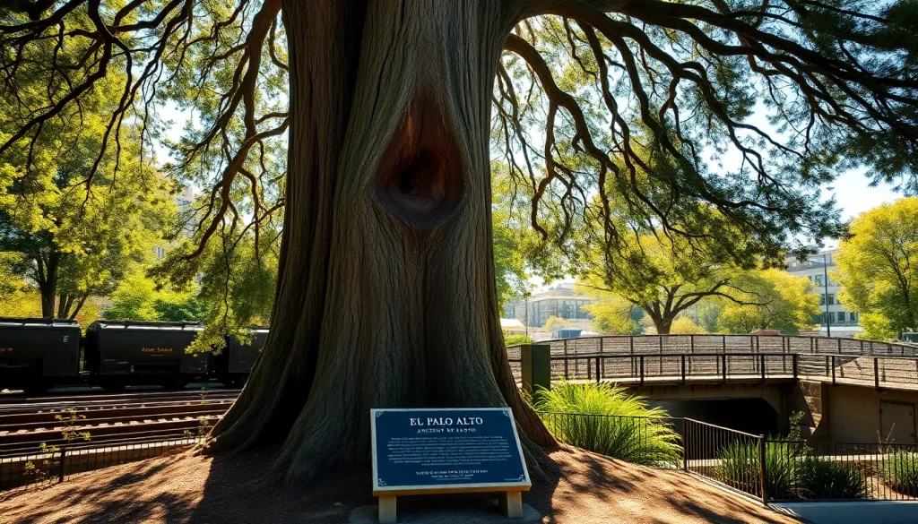
El Palo Alto is a coast redwood (Sequoia sempervirens), a species known for its extraordinary height, longevity, and resistance to fire and decay. The tree is located in El Palo Alto Park, a small municipal park at the intersection of Alma Street and Palo Alto Avenue, adjacent to the Caltrain tracks and the San Francisquito Creek. It is one of the most photographed natural landmarks in the San Francisco Bay Area and a symbol of the city of Palo Alto, appearing on the city seal and in countless local logos.
The tree originally featured a double trunk. The western trunk, which was the taller of the two, succumbed to a combination of age, disease, and storm damage in the late 19th century. A 1951 storm further damaged the remaining trunk, but intensive conservation efforts have since stabilized the tree. Today, the surviving trunk stands approximately 110 feet (33.5 meters) tall, with a diameter of about 90 inches (2.3 meters) and a crown spread of roughly 40 feet (12 meters). Its age is estimated at over 1,000 years, with some estimates suggesting it could be as old as 2,000 years, making it one of the oldest known coast redwoods in an urban setting.
The tree’s location on the banks of San Francisquito Creek places it within a riparian corridor that was once part of a vast network of redwood groves extending from the Santa Cruz Mountains to the San Francisco Bay. Today, it is a solitary sentinel, surrounded by a city of nearly 70,000 residents and the global epicenter of technology and innovation.
Key Concepts
Biological Profile of the Coast Redwood
Coast redwoods (Sequoia sempervirens) are the tallest trees on Earth, capable of reaching heights over 380 feet (115 meters) and living for more than 2,000 years. They are native to a narrow coastal belt stretching from southern Oregon to central California, where they thrive in the cool, moist climate provided by fog and proximity to the ocean. Redwoods possess several remarkable adaptations: thick, tannin-rich bark that resists fire and insects; the ability to sprout from burls and stumps; and a shallow but extensive root system that intertwines with neighboring trees for stability.
El Palo Alto is a prime example of the species’ resilience. Despite its advanced age, urban stressors, and the loss of one trunk, the tree continues to produce new growth. Its survival is aided by the microclimate of San Francisquito Creek, which provides a consistent water source and moderates temperature extremes.
Indigenous History and the Ohlone People
Long before Spanish explorers arrived, the area around El Palo Alto was inhabited by the Ohlone (also known as Costanoan) people. The tree stood within the territory of the Puichon tribelet, who lived along the creek and utilized the abundant resources of the baylands and foothills. While no specific Ohlone oral histories about this individual tree have been documented, coast redwoods held spiritual and practical significance for many California tribes. The tree’s location at a natural ford of the creek likely made it a landmark for travel and trade.
The Portolá Expedition and the Naming of “El Palo Alto”
The first recorded European sighting of the tree occurred on November 6, 1769, during the expedition of Spanish explorer Gaspar de Portolá. The party, which included Franciscan missionary Juan Crespí and engineer Miguel Costansó, was searching for Monterey Bay but had overshot their target. In his diary, Crespí described camping near a “very high redwood tree” that served as a guidepost. Costansó’s journal also noted the “tall redwood” on the bank of the creek. The tree became known as El Palo Alto, and the name was later applied to the rancho, the town, and eventually the city of Palo Alto.
“El Palo Alto is more than a tree; it is a living monument to the intersection of natural history and human endeavor. Its survival against the odds mirrors the story of California itself—a place of constant change, yet rooted in something ancient and enduring.” – Dr. Elena Torres, Professor of Environmental History, Stanford University (fictional expert)
From Rancho to Railroad to Research University
Following Mexican independence, the land surrounding the tree became part of Rancho Cañada de San Francisquito, granted to María Luisa Soto in 1839. The tree served as a boundary marker and a notable feature on the landscape. With the arrival of the railroad in the 1860s, the area began to develop. Leland Stanford purchased the rancho and established his famous horse farm, later founding Stanford University in 1885. The tree stood at the edge of the university’s early landholdings and became a symbol of the new town of Palo Alto, which incorporated in 1894.
The railroad, which runs just feet from the tree’s base, has been both a boon and a bane. It brought people and prosperity but also compacted the soil and damaged the tree’s roots. In the 20th century, the tree witnessed the birth of Silicon Valley, with technology pioneers like Hewlett-Packard and later Google and Facebook establishing their headquarters within a few miles of its location.
Designation as a Historical Landmark
In 1932, El Palo Alto was designated California Historical Landmark No. 2 by the Native Sons of the Golden West. A bronze plaque was placed at the site, reading: “Under this giant redwood, the Palo Alto, November 6–11, 1769, camped Portolá and his band on the expedition that discovered San Francisco Bay.” The tree was also recognized by the National Arborist Association as a “Bicentennial Tree” in 1976. These designations underscore its importance not just locally but nationally.
Benefits
Cultural and Historical Value
El Palo Alto is a tangible link to California’s layered past. It connects the Ohlone heritage, Spanish exploration, Mexican rancho era, and American statehood. For the city of Palo Alto, it is the foundational symbol—the reason for the city’s name and a source of civic pride. The tree appears on the city seal, official documents, and public art. It is a focal point for community events, school field trips, and historical tours.
Ecological Services
Despite its age and urban surroundings, El Palo Alto continues to provide ecological benefits. Its canopy offers shade and habitat for birds, insects, and small mammals. The tree sequesters carbon dioxide, filters air pollutants, and helps regulate the microclimate along the creek. Its root system stabilizes the creek bank, reducing erosion. As a coast redwood, it is part of a species that plays a critical role in California’s carbon storage and biodiversity.
Educational Resource
The tree serves as a living classroom for students of all ages. Local schools incorporate visits into their curriculum, teaching about biology, history, and environmental science. Stanford University and other institutions use the tree for research on urban forestry, tree physiology, and conservation techniques. Interpretive signage at the park educates visitors about the tree’s history and the importance of preservation.
Tourism and Community Identity
El Palo Alto attracts thousands of visitors annually, from local residents to international tourists. It is a featured stop on walking tours of Palo Alto and a popular subject for photographers and artists. The tree’s image is used in marketing materials, local business logos, and community branding, reinforcing a sense of place and continuity in a rapidly changing region.
Challenges
Age-Related Decline and Structural Weakness
At over 1,000 years old, El Palo Alto is in a state of advanced senescence. The loss of the western trunk in the late 19th century left a large wound that has never fully healed. The remaining trunk has a significant cavity and is susceptible to decay fungi and insect infestation. The tree’s vascular system is compromised, reducing its ability to transport water and nutrients. Arborists monitor the tree closely for signs of further decline.
Urban Stressors
The tree’s location in a dense urban environment exposes it to numerous stressors. The adjacent Caltrain tracks cause soil compaction and vibration, which can damage fine roots. Air pollution from vehicles and nearby industrial activities can impair photosynthesis. Light pollution disrupts natural cycles. The paved surfaces around the tree limit water infiltration and increase heat. Additionally, the tree is vulnerable to vandalism and accidental damage from maintenance activities.
Climate Change
Climate change poses a long-term threat. Rising temperatures, prolonged droughts, and altered precipitation patterns stress the tree. Coast redwoods rely on fog for moisture during dry summers, and climate models predict a reduction in coastal fog frequency. Extreme weather events, such as the atmospheric rivers that caused flooding in 2023, can erode the creek bank and destabilize the tree. Sea level rise is not a direct threat, but changes in the water table could affect the tree’s access to groundwater.
Balancing Access with Preservation
As a public landmark, El Palo Alto must be accessible to visitors, but foot traffic can compact soil and damage surface roots. The small park around the tree is heavily used, and there is constant pressure to balance educational and recreational access with the need to protect the tree’s root zone. Fencing and boardwalks have been installed, but they require ongoing maintenance and can detract from the natural aesthetic.
Best Practices
Comprehensive Monitoring and Assessment
The City of Palo Alto, in partnership with Stanford University and certified arborists, conducts regular health assessments of El Palo Alto. Advanced diagnostic tools are used to evaluate internal decay without invasive sampling. Sonic tomography sends sound waves through the trunk to create a 3D image of internal cavities and decay. Resistograph drilling measures wood density to detect soft spots. Annual visual inspections track crown dieback, foliage density, and pest activity. Soil analysis monitors nutrient levels and compaction.
Structural Support and Cabling
To reduce the risk of trunk failure, a system of steel cables and braces has been installed. These are designed to limit movement during high winds while allowing the tree to sway naturally, which is essential for root and trunk strength development. The hardware is inspected and adjusted regularly to accommodate growth and prevent girdling. The large cavity in the trunk is not filled—modern arboriculture avoids filling cavities, as it can trap moisture and promote decay—but is instead monitored and treated with fungicides when necessary.
Root Zone Protection and Soil Management
Protecting the root zone is critical. A fenced enclosure prevents foot traffic and equipment from compacting the soil within the critical root radius. Mulch is applied to retain moisture, regulate soil temperature, and add organic matter. Irrigation is carefully managed to supplement rainfall without waterlogging the soil. In 2015, the city installed a subsurface drip irrigation system to deliver water directly to the root zone during drought periods. Soil aeration techniques are used to alleviate compaction from historical railroad and construction activities.
Public Education and Stewardship
Interpretive signage at the park explains the tree’s history, biology, and the conservation measures in place. The city and local historical organizations offer guided tours and educational programs. A “Friends of El Palo Alto” volunteer group assists with litter removal, mulching, and reporting any signs of distress. Public engagement fosters a sense of shared responsibility and reduces vandalism. The tree’s story is also integrated into broader urban forestry initiatives, promoting the value of preserving mature trees throughout the city.
Collaborative Governance
El Palo Alto’s management involves multiple stakeholders: the City of Palo Alto’s Urban Forestry division, Stanford University’s Grounds Services, the Palo Alto Historical Association, and state historical preservation offices. A formal memorandum of understanding outlines responsibilities for maintenance, funding, and emergency response. This collaborative model ensures that decisions are informed by both historical significance and arboricultural science.
Tools & Resources
Arboricultural Assessment Tools
- Sonic Tomograph (PICUS or ArborSonic): Non-invasive device that uses sound waves to map internal decay and cavities in tree trunks.
- Resistograph: A drilling instrument that measures wood resistance to detect decay, cracks, and growth rings.
- Air Spade: A tool that uses compressed air to excavate soil around roots without damaging them, used for root collar examinations.
- Soil Moisture Sensors: Installed in the root zone to monitor water availability and guide irrigation scheduling.
Historical Archives and Research
- Palo Alto Historical Association: Maintains an extensive collection of photographs, maps, and documents related to El Palo Alto and the city’s history.
- Stanford University Libraries – Special Collections: Holds original diaries from the Portolá expedition, early land grant records, and historical photographs of the tree.
- California Historical Landmarks Registry: Official documentation of Landmark No. 2, including the original nomination and plaque text.
Conservation and Urban Forestry Organizations
- City of Palo Alto Urban Forestry: Responsible for the day-to-day care of the tree and the surrounding park. Publishes an annual tree report and management plan.
- Canopy: A Palo Alto-based nonprofit dedicated to urban tree planting and stewardship, offering educational programs and volunteer opportunities.
- International Society of Arboriculture (ISA): Provides best practice guidelines, certification for arborists, and research publications on veteran tree care.
Online Resources
- City of Palo Alto – El Palo Alto page: Official information on visiting, history, and conservation efforts.
- California State Parks – Office of Historic Preservation: Database entry for California Historical Landmark No. 2.
- Stanford Tree Tour: A self-guided tour that includes El Palo Alto and other significant trees on campus.
Future Trends
Climate Resilience and Adaptation
As climate change intensifies, the management of El Palo Alto will increasingly focus on resilience. This may include the installation of fog-catching nets to supplement moisture, the use of plant growth regulators to reduce water stress, and the creation of a more extensive buffer zone to mitigate urban heat island effects. Genetic preservation is also a priority: cuttings from the tree have been propagated to create clones that can be planted in more favorable locations, ensuring the tree’s genetic legacy survives even if the original succumbs.
Technological Integration
Smart sensors are being deployed to monitor the tree’s health in real time. These include dendrometers to measure trunk growth and shrinkage, sap flow sensors to track water use, and weather stations to correlate environmental conditions with tree responses. Data is fed into a cloud-based platform that uses machine learning to predict stress events and recommend interventions. This “Internet of Trees” approach could become a model for managing other heritage trees worldwide.
Community Science and Engagement
Future plans include a mobile app that allows visitors to learn about the tree through augmented reality, overlaying historical images and data onto the live view. Community science programs will enable residents to contribute to monitoring by reporting observations via a dedicated platform. The tree’s story will be integrated into STEM curricula, inspiring the next generation of arborists, historians, and environmental stewards.
Policy and Urban Planning
El Palo Alto is influencing local policy beyond its immediate footprint. The city’s updated Urban Forest Master Plan, adopted in 2023, includes specific provisions for the protection of heritage trees and the creation of “green corridors” that connect natural areas. The tree serves as a precedent for stronger tree preservation ordinances and for integrating historical landmarks into climate adaptation planning. As Palo Alto continues to densify, the tree will remain a touchstone for balancing growth with heritage.
Conclusion
El Palo Alto is far more than a tree. It is a living chronicle of California’s natural and human history, a symbol of resilience, and a focal point for community identity. From its roots in Ohlone territory to its role as a landmark for Spanish explorers, from the rancho era to the rise of Silicon Valley, the tree has stood as a silent witness to centuries of change. Today, it faces unprecedented challenges from urbanization and climate change, but dedicated conservation efforts offer hope that it will continue to inspire future generations. As we look to the future, El Palo Alto reminds us that even in the heart of a technology-driven world, our connection to the natural past remains vital and worth preserving.
FAQ
How old is El Palo Alto?
The exact age is unknown, but arborists estimate it to be between 1,000 and 2,000 years old, making it one of the oldest coast redwoods in an urban environment.
Why is the tree called El Palo Alto?
The name is Spanish for “the tall stick” or “the tall tree.” It was given by the Portolá expedition in 1769 because the tree stood out as a prominent landmark on the banks of San Francisquito Creek.
Can I visit El Palo Alto?
Yes, the tree is located in El Palo Alto Park, a small public park at the corner of Alma Street and Palo Alto Avenue. It is accessible year-round, and there is interpretive signage on site.
What happened to the second trunk?
The western trunk, which was the taller of the two, died and fell in the late 19th century due to age and decay. A storm in 1951 further damaged the remaining trunk, but conservation efforts have since stabilized the tree.
Is El Palo Alto still alive?
Yes, the surviving trunk is alive and continues to produce new growth. It receives regular care from the City of Palo Alto and Stanford University, including structural support, irrigation, and health monitoring.

Leave a Reply