
Short Answer
Introduction
San Francisquito Creek rises from the eastern slopes of the Santa Cruz Mountains and flows 13 miles to San Francisco Bay, carving a natural border between San Mateo and Santa Clara counties. For millennia, this modest waterway has sustained indigenous communities, shaped the landscape of the Peninsula, and served as a critical habitat for threatened steelhead trout. Yet its serene appearance belies a volatile nature: the creek is one of the most flood‑prone channels in the Bay Area, with a history of devastating overflows that have reshaped local policy and infrastructure. This article provides an encyclopedic examination of San Francisquito Creek—its geological origins, cultural significance, ecological richness, flood dynamics, and the multi‑agency efforts to create a resilient future for the watershed.
Overview
The San Francisquito Creek watershed drains approximately 45 square miles, encompassing portions of Portola Valley, Woodside, Menlo Park, Palo Alto, and East Palo Alto. The main stem begins at the confluence of Bear Creek and Corte Madera Creek below Searsville Dam, a 65‑foot‑high structure built in 1892 that has profoundly altered the creek’s hydrology and sediment transport. Downstream, the creek meanders through alluvial flats before entering a heavily engineered flood control channel and eventually discharging into the Baylands, a vast expanse of tidal marshes and salt ponds. The watershed is a microcosm of California’s water challenges: it supports endangered species, provides recreational opportunities, and poses a significant flood threat to densely populated urban areas. The San Francisquito Creek Joint Powers Authority (SFCJPA), formed in 1999, coordinates flood protection and ecosystem restoration among five member agencies.
Key Concepts
Geological and Hydrological Setting
The creek’s headwaters lie in the tectonically active Santa Cruz Mountains, where steep terrain and highly erodible Franciscan Complex rocks generate substantial sediment. Annual precipitation averages 25 inches in the upper watershed but can exceed 50 inches during wet El Niño years. The creek’s flow regime is highly seasonal, with peak discharges typically occurring between December and March. Baseflow is sustained by groundwater seepage from the alluvial aquifer, which is recharged by percolation through the creek bed. This groundwater‑surface water interaction is vital for maintaining summer streamflows and cool water temperatures needed by steelhead.
Indigenous Stewardship and Early History
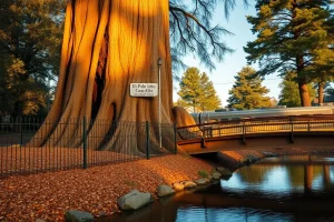
For over 2,000 years, the creek was home to the Puichon band of the Ohlone people, who established seasonal villages along its banks. They harvested steelhead, freshwater mussels, and tule reeds, and practiced controlled burns to manage riparian vegetation. The creek’s name derives from the Spanish “San Francisquito” (Little St. Francis), given by the Portolá expedition in 1769 when they camped near its mouth. The area later became part of the Rancho San Francisquito land grant, and the creek served as a vital water source for early Californio ranching. The famous tree El Palo Alto, a redwood that marked a campsite for Spanish explorers, still stands on the creek’s bank and is a California Historical Landmark.
Ecological Significance
San Francisquito Creek is one of the few Bay Area streams that still supports a wild run of Central California Coast steelhead trout (Oncorhynchus mykiss), a federally threatened species. The watershed provides spawning and rearing habitat in the upper reaches, while the lower creek and Baylands offer critical estuarine habitat for juvenile fish transitioning to saltwater. The riparian corridor hosts a diverse assemblage of native plants, including willows, cottonwoods, and sycamores, which provide food and shelter for over 150 bird species, mammals such as gray foxes and raccoons, and amphibians like the California red‑legged frog. The Baylands at the creek’s mouth are part of the Don Edwards San Francisco Bay National Wildlife Refuge, a key stopover on the Pacific Flyway.
Flood Risk and the 1998 Event
The creek’s flood risk stems from a combination of intense rainfall, steep upper watershed, and a constricted channel through urban areas. The flood of record occurred on February 3, 1998, when a Pineapple Express storm dropped up to 10 inches of rain in 24 hours. The creek overtopped its banks in multiple locations, inundating more than 1,700 homes and businesses in Palo Alto, Menlo Park, and East Palo Alto, causing over $28 million in damages (1998 dollars). The disaster exposed critical weaknesses in the existing flood control system, including undersized bridges and a lack of upstream detention. It also highlighted social inequities, as the predominantly low‑income community of East Palo Alto suffered disproportionately. The event galvanized the formation of the SFCJPA and a renewed focus on watershed‑wide flood management.
Benefits
Ecosystem Services
A healthy San Francisquito Creek provides numerous ecosystem services. The riparian forest filters pollutants, stabilizes banks, and sequesters carbon. The creek’s groundwater recharge function helps sustain local water supplies, reducing reliance on imported water. The Baylands act as a natural buffer against storm surges and sea‑level rise, protecting adjacent neighborhoods. Additionally, the creek corridor offers recreational and educational opportunities, with trails like the San Francisquito Creek Trail connecting communities to nature. The presence of steelhead trout and other wildlife enhances biodiversity and provides intrinsic value that supports local identity and heritage.
Flood Protection for Communities
Since 1998, significant investments have been made to reduce flood risk. The SFCJPA’s multi‑phase project has widened the channel downstream of Highway 101, replaced or modified bridges, and constructed setback levees to convey 100‑year flood flows safely to the Bay. These improvements have already reduced the floodplain extent for a 10‑year event by over 50% in some reaches. When fully implemented, the project aims to provide 100‑year flood protection for the urbanized floodplain, safeguarding over 5,000 properties and critical infrastructure, including U.S. Highway 101 and the Caltrain rail line. The project also incorporates ecosystem enhancements, such as replanting native vegetation and creating off‑channel habitat for fish.
Cultural and Historical Preservation
Efforts to manage the creek have increasingly recognized the importance of preserving cultural resources. The SFCJPA works with Ohlone descendants and local historical societies to protect archaeological sites and interpret the creek’s indigenous history. El Palo Alto Park, managed by the City of Palo Alto, maintains the iconic redwood and provides interpretive signage about the area’s Spanish and Mexican heritage. These initiatives foster a sense of place and educate the public about the deep human connections to the watershed.
Challenges
Balancing Flood Control and Ecology
One of the most persistent challenges is reconciling the need for flood conveyance with ecological restoration. Traditional flood control methods, such as channelization and concrete lining, destroy habitat and disconnect the creek from its floodplain. Modern approaches seek to mimic natural processes, but they often require more land and higher costs. For example, widening the channel to accommodate flood flows can conflict with the preservation of mature riparian trees that provide shade and habitat. The SFCJPA must navigate these trade‑offs while meeting regulatory requirements under the Endangered Species Act and Clean Water Act.
Sedimentation and Searsville Dam
Searsville Dam, owned by Stanford University, has trapped an estimated 2.7 million cubic yards of sediment since its construction, reducing reservoir capacity by over 90%. This sediment starvation downstream has caused channel incision and coarsening of the bed, degrading steelhead spawning habitat. The dam also blocks fish passage to over 20 miles of pristine upstream habitat. Stanford is currently evaluating options for the dam’s future, including potential removal or modification, but the decision involves complex trade‑offs among water supply, flood risk, and ecosystem benefits. The accumulated sediment contains legacy mercury from historic mining, complicating any removal scenario.
Climate Change and Sea‑Level Rise
Climate change is intensifying the creek’s flood risk. Projections indicate more frequent and intense atmospheric river storms, which could increase peak discharges by 20–30% by mid‑century. Simultaneously, sea‑level rise threatens to raise the Bay’s water level, reducing the creek’s gradient and ability to drain during storms. The lower creek and Baylands are already experiencing increased tidal flooding during king tides. Adapting the flood control system to these dual pressures requires flexible, adaptive management strategies and significant additional investment.
Funding and Interagency Coordination
Implementing large‑scale watershed projects requires sustained funding from federal, state, and local sources. The SFCJPA’s capital improvement program is estimated to cost over $200 million, with funding gaps remaining for future phases. Coordinating among five member agencies, multiple regulatory bodies, and community stakeholders adds complexity and can slow decision‑making. Ensuring equitable distribution of benefits and burdens, particularly for disadvantaged communities like East Palo Alto, remains a critical concern.
Best Practices
Integrated Watershed Management
The SFCJPA exemplifies an integrated approach that considers the entire watershed, from headwaters to Bay. This includes combining structural measures (levees, bypass channels) with non‑structural measures (floodplain zoning, early warning systems). The agency uses two‑dimensional hydraulic modeling to evaluate project alternatives and optimize benefits for both flood protection and habitat. Public engagement is embedded throughout the planning process, with community workshops and multilingual outreach materials.
Nature‑Based Solutions
Where feasible, the project incorporates nature‑based solutions such as vegetated levees, floodplain reconnection, and creation of off‑channel rearing habitat for steelhead. These features provide multiple benefits: they attenuate flood peaks, improve water quality, and enhance biodiversity. For instance, the recently completed Reach 2 project downstream of Highway 101 created a wider, terraced channel with native plantings that slow floodwaters while providing cover for juvenile fish. Such designs are more resilient to climate change than traditional concrete channels.
Adaptive Management and Monitoring
Given the uncertainties of climate change and ecosystem response, adaptive management is essential. The SFCJPA has implemented a comprehensive monitoring program that tracks streamflow, groundwater levels, water quality, geomorphic changes, and fish populations. Data are used to adjust operations and inform future project phases. For example, if monitoring shows that steelhead are not utilizing newly created habitat, designs can be modified to improve conditions. This iterative learning process is a model for other urban stream restoration projects.
Tools & Resources
Key Data Sources and Models
- USGS Stream Gauge 11164500: Provides real‑time flow data for San Francisquito Creek at Menlo Park, essential for flood forecasting and research.
- SFCJPA Hydraulic Models: Two‑dimensional HEC‑RAS models used to simulate flood scenarios and evaluate project alternatives.
- NOAA Fisheries Steelhead Recovery Plan: Outlines recovery actions for Central California Coast steelhead, including targets for San Francisquito Creek.
- Santa Clara Valley Water District Flood Risk Maps: Updated FEMA flood insurance rate maps and local hazard assessments.
- Stanford University Searsville Study: Ongoing feasibility study for the future of Searsville Dam, including sediment management and fish passage options.
Community and Educational Resources
- San Francisquito Creek Trail: A multi‑use path along the lower creek offering interpretive signs about ecology and history.
- Acterra’s Creek Connections Program: Volunteer‑based water quality monitoring and restoration events.
- Palo Alto Baylands Nature Preserve: Provides access to the creek mouth and tidal marshes, with a nature center and guided walks.
- SFCJPA Website: Offers project updates, meeting agendas, and educational materials on flood preparedness.
Future Trends
Dam Removal and Sediment Management
The potential removal or modification of Searsville Dam represents a transformative opportunity for the watershed. If the dam is removed, it would reconnect over 20 miles of high‑quality steelhead habitat and restore natural sediment transport. However, the process would require careful management of accumulated sediment to avoid downstream impacts. Pilot projects to bypass sediment around the dam are being explored as an interim measure. The outcome of Stanford’s feasibility study, expected in the coming years, will shape the watershed’s future for decades.
Climate Adaptation and Resilient Design
Future flood management will increasingly incorporate climate projections. The SFCJPA is working with scientists to downscale climate models and assess the combined effects of increased storm intensity and sea‑level rise. Designs for downstream levees and floodwalls are being evaluated for adaptability, such as adding height in the future or incorporating living shorelines that can accrete with sea‑level rise. The Baylands could be managed to enhance their natural flood storage capacity through sediment augmentation and marsh restoration.
Green Infrastructure and Urban Retrofits
Upstream communities are beginning to implement green infrastructure to reduce stormwater runoff and improve water quality. Rain gardens, permeable pavements, and cisterns can attenuate peak flows and reduce the burden on the creek. The City of Palo Alto’s Urban Forest Master Plan and Stormwater Management Plan include goals to increase tree canopy and infiltrate runoff, which could have measurable benefits for the creek’s hydrology. Scaling up these efforts across the watershed will require incentives and policy changes.
“San Francisquito Creek is a microcosm of California’s water challenges—balancing flood protection, ecological restoration, and historical preservation. The lessons we learn here will inform urban stream management across the state.” — Dr. Elena Marquez, Senior Watershed Scientist, San Francisquito Creek Joint Powers Authority
Conclusion
San Francisquito Creek is far more than a line on a map. It is a dynamic system that has shaped human settlement for millennia and continues to define the relationship between nature and urban life on the Peninsula. The creek’s history of devastating floods has spurred innovative, multi‑benefit solutions that seek to protect communities while reviving ecological function. As climate change accelerates, the watershed will test our ability to adapt and collaborate. By understanding its past and present, we can chart a course toward a resilient future where the creek thrives alongside the people who depend on it.
FAQ
What caused the 1998 flood of San Francisquito Creek?
The 1998 flood was triggered by a Pineapple Express storm that dropped up to 10 inches of rain in 24 hours on already saturated ground. The creek’s channel was too narrow to convey the flow, and undersized bridges created bottlenecks, causing water to overtop banks and inundate over 1,700 properties.
Are there steelhead trout in San Francisquito Creek?
Yes, San Francisquito Creek supports one of the few remaining wild runs of Central California Coast steelhead trout, a federally threatened species. They spawn in the upper reaches, but their access to historic habitat is blocked by Searsville Dam.
How is flood risk being managed today?
The San Francisquito Creek Joint Powers Authority (SFCJPA) is implementing a multi-phase project to widen the channel, replace bridges, and construct setback levees to safely convey a 100-year flood. The project also includes ecosystem restoration and is designed to adapt to climate change.
What is the significance of Searsville Dam?
Searsville Dam, built in 1892, has trapped sediment and blocked steelhead from over 20 miles of upstream habitat. Stanford University is studying options for its future, including potential removal, which could restore natural processes but involves complex sediment management.


Leave a Reply