Short Answer
Quick Answer
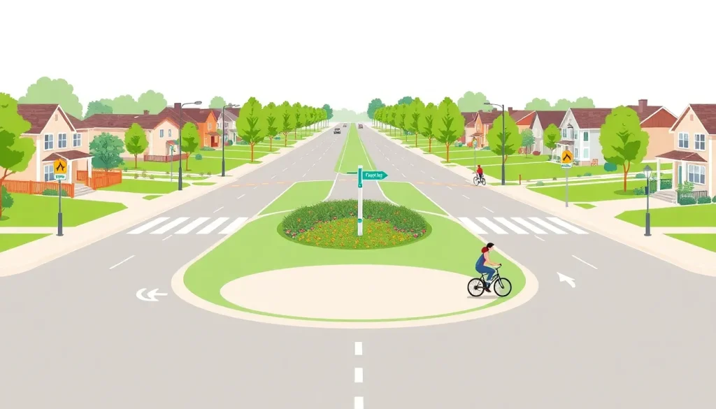
Palo Alto’s Bicycle Boulevard Network is a system of low-traffic, low-speed streets optimized for bicycle travel through signage, pavement markings, and traffic-calming measures. Managed by the City of Palo Alto’s Office of Transportation, the network prioritizes cyclist comfort and safety while maintaining local access for motor vehicles. As of 2025, the network includes over 12 miles of designated routes, with ongoing expansions guided by the city’s Bicycle and Pedestrian Transportation Plan.
What Is Palo Alto’s Bicycle Boulevard Network?
A bicycle boulevard is a street where bicycle traffic is given priority over motor vehicle through-traffic, creating a safe, low-stress environment for people on bikes. Palo Alto’s network is one of the oldest and most studied in the United States, with the Bryant Street Bicycle Boulevard—established in 1982—often cited as the nation’s first modern bicycle boulevard. The concept emerged from a grassroots effort to create a safe east-west route for cyclists, particularly children traveling to school, and has since evolved into a citywide network of interconnected corridors.
The network is designed to serve riders of all ages and abilities, from experienced commuters to families with young children. Key design elements include:
- Traffic circles and roundabouts that slow motor vehicles and reduce the need for stop signs.
- Partial and full diverters that prevent cut-through motor traffic while allowing bicycles and pedestrians to pass.
- Wayfinding signage with destination arrows and distance markers.
- Shared lane markings (sharrows) and green-backed signs that reinforce the street’s bicycle priority.
- Crossing improvements at major streets, including pedestrian-activated signals and median refuges.
Unlike a traditional bike lane, a bicycle boulevard does not typically include a separated path. Instead, the entire roadway is shared, but the volume and speed of motor vehicles are kept low enough that most cyclists feel comfortable riding in the travel lane. The network connects to schools, parks, shopping districts, transit stations, and employment centers, making it a backbone for non-motorized mobility.
Who Manages It?
The Bicycle Boulevard Network is managed by the City of Palo Alto’s Office of Transportation, which sits within the Department of Public Works. The Office of Transportation is responsible for planning, design, implementation, and maintenance of all bicycle and pedestrian infrastructure. Key contacts include the city’s Transportation Planning Manager and the Bicycle and Pedestrian Coordinator, though names change over time; residents can reach the office via the city’s general information line at (650) 329-2100 or through the PaloAlto311 service request portal.
Policy direction comes from the City Council, which adopts the Bicycle and Pedestrian Transportation Plan (BPTP) and allocates funding. The BPTP is updated every five to seven years and sets the vision for network expansion. Day-to-day operations, such as sign replacement and pavement marking refresh, are handled by Public Works maintenance crews. The city also coordinates with regional agencies like the Santa Clara Valley Transportation Authority (VTA) and the Metropolitan Transportation Commission (MTC) for grant funding and regional connectivity.
Current Status
As of early 2025, the network comprises approximately 12.5 miles of designated bicycle boulevards, with several corridors in various stages of planning or construction. The most heavily used routes include:
- Bryant Street (south of Oregon Expressway to Embarcadero Road) – the original bicycle boulevard, recently upgraded with new traffic circles and green pavement markings.
- Lincoln Avenue – a north-south spine connecting the California Avenue business district to downtown.
- Moreno Avenue – a key east-west link through the Midtown neighborhood.
- Park Boulevard – a newer addition serving the southern part of the city.
In 2023, the City Council adopted an updated Bicycle and Pedestrian Transportation Plan that calls for expanding the network to 20 miles by 2030. Construction is currently underway on the East Meadow Drive Bicycle Boulevard, which will close a critical gap between Middlefield Road and Alma Street. The project includes installation of a new traffic signal at East Meadow and Alma, raised crosswalks, and a neighborhood traffic circle. Funding comes from a combination of local transportation impact fees, VTA grants, and state Active Transportation Program funds.
Residents can track project statuses on the city’s Palo Alto Transportation Projects web page, which includes interactive maps and timelines.
How Residents Use It
Using the bicycle boulevard network is straightforward, but a little planning can make trips safer and more enjoyable. Follow these steps:
- Plan your route. Visit the city’s online Bike Map (available at cityofpaloalto.org/bikemap) or pick up a printed copy at City Hall or local libraries. The map highlights bicycle boulevards in purple and shows connections to bike lanes, paths, and transit. You can also use navigation apps like Google Maps with the “bicycling” layer enabled, though the city’s map is more detailed for local nuances.
- Identify your entry point. Bicycle boulevards are marked with green signs and pavement legends. Look for the “Bicycle Boulevard” sign at the beginning of the route. If you’re joining mid-block, you’ll see sharrows and wayfinding signs.
- Ride predictably and share the road. Cyclists are encouraged to ride in the center of the travel lane when necessary for safety. Motor vehicles are permitted but must yield to bicycles and keep speeds low. Pass with care, and always stop for pedestrians at crosswalks.
- Navigate intersections carefully. At major cross streets, use the designated crossing treatments—some have push-button signals, others have median islands. At traffic circles, yield to vehicles already in the circle and signal your intentions.
- Report issues. If you encounter faded markings, damaged signs, or unsafe conditions, submit a service request via PaloAlto311 (online or mobile app) or call (650) 329-2413. The city tracks these reports and prioritizes maintenance.
Relevant Map or Dataset
The City of Palo Alto publishes an interactive Bicycle Boulevards Map as part of its open data portal. The map displays all existing and planned bicycle boulevard corridors, along with traffic calming features, crossing improvements, and connection points to other bike infrastructure. Users can toggle layers to see pavement condition ratings, average daily traffic counts, and collision history (from the California Statewide Integrated Traffic Records System).
Below is a sample of the data points available in the city’s Bicycle Boulevards GIS layer, which can be downloaded as a shapefile or viewed on the portal:
| Data Point | Description | Source |
|---|---|---|
| Total network miles | 12.5 miles of designated bicycle boulevards | City of Palo Alto GIS, 2025 |
| Number of corridors | 8 distinct bicycle boulevard streets | Palo Alto BPTP 2023 |
| Traffic circles installed | 34 neighborhood traffic circles | Public Works asset inventory |
| Average daily cyclists (Bryant St.) | Approximately 1,200–1,500 cyclists per weekday | City bicycle counts, 2024 |
| Collision rate reduction | 38% fewer bicycle-involved collisions on boulevards vs. comparable arterials | BPTP safety analysis, 2023 |
The map is accessible at data.cityofpaloalto.org under the “Transportation” category. Residents can use it to explore routes, check for construction updates, and provide feedback on proposed projects.
Key Terminology
- Bicycle Boulevard: A low-traffic street optimized for bicycle through-travel, using traffic calming and wayfinding to prioritize cyclists while maintaining local vehicle access.
- Traffic Calming: Physical design features—such as speed humps, chicanes, and traffic circles—that reduce vehicle speeds and volumes.
- Sharrow (Shared Lane Marking): A pavement marking consisting of a bicycle symbol with two chevrons, indicating that cyclists may use the full lane and alerting drivers to expect bicycles.
- Diverter: A barrier that prevents motor vehicles from continuing straight through an intersection while allowing bicycles and pedestrians to pass.
- Level of Traffic Stress (LTS): A rating system from 1 (suitable for children) to 4 (only for confident, experienced cyclists) that measures the comfort and safety of a cycling route.
Limitations and Caveats
While the bicycle boulevard network is a national model, it has several limitations residents should understand:
- Incomplete build-out: Not all designated boulevards have the full suite of traffic calming features. Some segments still rely on stop signs and lack diverters, which can lead to higher motor vehicle volumes than intended.
- Data freshness: Bicycle count data is collected periodically, not continuously. The most recent system-wide counts date to 2024, and some corridors have not been counted since 2022. Real-time usage data is not publicly available.
- Enforcement gaps: Speed limits on boulevards are 25 mph, but enforcement is complaint-driven. Residents occasionally report cut-through traffic, especially during peak hours.
- Connectivity gaps: The network is not yet seamless. Some routes end abruptly at major barriers like Highway 101 or the Caltrain tracks, requiring detours onto busier streets.
- Equity considerations: The network is concentrated in central and south Palo Alto. North Palo Alto neighborhoods have fewer designated boulevards, a gap the 2023 plan aims to address.
Update History
- 2025-01: East Meadow Drive Bicycle Boulevard construction begins; expected completion fall 2025.
- 2023-06: City Council adopts updated Bicycle and Pedestrian Transportation Plan, setting 20-mile network goal.
- 2021-09: Bryant Street Bicycle Boulevard receives green pavement markings and new wayfinding signs as part of a “quick-build” refresh.
- 2017-04: Park Boulevard Bicycle Boulevard opens, adding 1.8 miles to the network.
- 2012-11: City launches online interactive bike map with bicycle boulevard layer.
- 1982-05: Bryant Street Bicycle Boulevard dedicated, becoming one of the first in the United States.
Official Sources
- City of Palo Alto – Bicycle and Pedestrian Transportation Plan: https://www.cityofpaloalto.org/Departments/Transportation/Bicycle-Pedestrian-Plan
- City of Palo Alto – Bike Map: https://www.cityofpaloalto.org/Departments/Transportation/Bike-Map
- PaloAlto311 Service Request Portal: https://www.cityofpaloalto.org/311
- City of Palo Alto Open Data Portal – Transportation datasets: https://data.cityofpaloalto.org
- California Statewide Integrated Traffic Records System (SWITRS): https://www.chp.ca.gov/programs-services/services-information/switrs-internet-statewide-integrated-traffic-records-system
FAQ
Do I have to stop at stop signs on a bicycle boulevard?
Yes. Unless a traffic circle or other treatment replaces the stop sign, cyclists must obey all traffic control devices, including stop signs. However, many intersections on bicycle boulevards have been converted to traffic circles, which require yielding rather than a full stop.
Are e-bikes allowed on bicycle boulevards?
Yes. Class 1 and Class 2 e-bikes are permitted on all bicycle boulevards and bike lanes in Palo Alto. Class 3 e-bikes (which can reach 28 mph) are allowed on streets but not on off-street paths. Riders must follow the same rules as traditional cyclists.
How can I request a new bicycle boulevard in my neighborhood?
Submit a request through PaloAlto311 or contact the Office of Transportation. The city evaluates potential new routes based on traffic volumes, connectivity gaps, and community support. The Bicycle and Pedestrian Transportation Plan update process is the primary venue for proposing new corridors.
Is the bicycle boulevard network plowed or swept in winter?
Palo Alto does not receive snow, but street sweeping occurs on a regular schedule. Bicycle boulevards are swept at least once a month. If debris or glass is reported via 311, the city dispatches a sweeper within 48 hours.

Leave a Reply