Short Answer
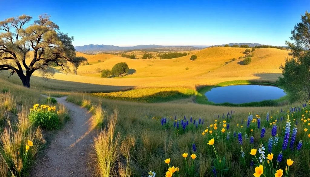
Pearson-Arastradero Preserve is a 622-acre open space located in the foothills of Palo Alto, California, offering a serene escape into rolling grasslands, oak woodlands, and riparian corridors. Managed by the City of Palo Alto, the preserve provides over 10 miles of trails for hiking, biking, and equestrian use, along with opportunities for wildlife viewing and environmental education. Its name reflects both the historic Arastradero Road and the Pearson family, who once owned the land. This article serves as a comprehensive guide to the preserve’s trails, history, amenities, and visitor regulations.
Park Overview
Pearson-Arastradero Preserve is a 622-acre open space located in the Santa Cruz Mountain foothills on the western edge of Palo Alto, California. The preserve features a mix of habitats including oak savanna, grassland, chaparral, and riparian woodland along Arastradero Creek. It is a popular destination for hiking, trail running, mountain biking, and equestrian activities, with a network of trails that connect to the larger Bay Area Ridge Trail system. The preserve is also home to a variety of wildlife, including deer, bobcats, coyotes, and numerous bird species. The landscape is characterized by gentle to moderately steep hills, with elevations ranging from approximately 200 to 600 feet above sea level. The preserve is open year-round and offers a quiet retreat from the urban environment, with interpretive signs and a self-guided nature trail.
Location and Map
The main entrance and parking area for Pearson-Arastradero Preserve is located at 1530 Arastradero Road, Palo Alto, CA 94304. The preserve is situated in the foothills of the Santa Cruz Mountains, just west of Interstate 280. The parking lot provides direct access to the trail network.
Hours
The preserve is open daily from 8:00 a.m. until sunset. The parking lot gate is locked at sunset; vehicles remaining after that time may be ticketed or towed. Pedestrian access is available from sunrise to sunset via the entrance gate. The preserve may close during extreme weather events, such as high fire danger or heavy rain that causes trail damage. Check the City of Palo Alto website for any temporary closures.
Size
Pearson-Arastradero Preserve encompasses 622 acres of open space. The trail network includes approximately 10.5 miles of designated trails, ranging from wide fire roads to narrow single-track paths. The preserve is part of a larger interconnected open space system that includes Foothills Park and the Palo Alto Baylands.
Amenities
| Amenity | Availability |
|---|---|
| Parking Lot | Yes, free; approximately 30 spaces |
| Restrooms | Portable toilet near parking area |
| Drinking Water | Not available; bring your own |
| Picnic Tables | Yes, a few near the parking lot |
| Benches | Limited, along some trails |
| Interpretive Signs | Yes, at trailheads and along the self-guided nature trail |
| Bike Racks | Yes, at the parking area |
| Trash Cans | No; pack out all trash |
| Dog Waste Bags | Not provided |
Accessibility
The preserve offers limited accessibility for visitors with mobility challenges. The main parking lot includes designated accessible parking spaces. The Arastradero Lake Trail, a 0.5-mile loop around the small lake, is a compacted dirt and gravel path that is relatively flat and may be navigable for some wheelchair users with assistance, though it does not meet full ADA slope and surface standards. Other trails are natural surface with steeper grades, narrow passages, and uneven terrain, making them unsuitable for standard wheelchairs. Accessible portable restrooms are available at the trailhead. Service animals are permitted on all trails, but pets are restricted to designated trails (see Rules).
Trails
The preserve features a network of multi-use trails open to hikers, mountain bikers, and equestrians. All trails are well-marked with numbered posts and directional signs. Below are the primary named trails.
Arastradero Lake Trail
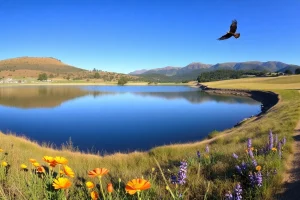
Distance: 0.5-mile loop. Difficulty: Easy. Surface: Compacted dirt and gravel. This short, flat loop circles the small seasonal lake and is the most accessible trail in the preserve. It offers excellent birdwatching and views of the surrounding hills. Benches are placed along the route. Dogs on leash are permitted on this trail only.
Meadowlark Trail
Distance: 1.1 miles one way. Difficulty: Easy to moderate. Surface: Dirt. The Meadowlark Trail runs from the parking area to the northern boundary, traversing open grasslands with wildflowers in spring. It connects to the Woodrat Trail and the Bay-to-Ridge Trail. Dogs on leash are allowed on the first 0.3 miles from the parking lot to the junction with Woodrat Trail.
Woodrat Trail
Distance: 1.2 miles one way. Difficulty: Moderate. Surface: Dirt, with some rocky sections. This trail climbs through oak woodland and chaparral, offering views of the preserve and the Santa Cruz Mountains. It connects the Meadowlark Trail to the Ohlone Trail. No dogs allowed.
Ohlone Trail
Distance: 1.5 miles one way. Difficulty: Moderate to strenuous. Surface: Dirt, steep in sections. The Ohlone Trail ascends to the highest point in the preserve, providing panoramic views of the Bay Area. It links to the Juan Bautista de Anza Trail and the Bay-to-Ridge Trail. No dogs allowed.
Bay-to-Ridge Trail
Distance: 1.8 miles within the preserve. Difficulty: Moderate. Surface: Dirt. This regional trail passes through Pearson-Arastradero as part of a larger planned route from San Francisco Bay to the Skyline Ridge. It traverses grasslands and oak woodlands, connecting to Foothills Park. No dogs allowed.
Juan Bautista de Anza Trail
Distance: 0.8 miles within the preserve. Difficulty: Easy to moderate. Surface: Dirt. This historic route follows the approximate path of the 1775–76 Spanish expedition. Within the preserve, it runs along the southern edge, offering views of Arastradero Creek. No dogs allowed.
Acorn Trail
Distance: 0.4 miles one way. Difficulty: Moderate. Surface: Dirt. A connector trail between the Meadowlark Trail and the Ohlone Trail, passing through a dense oak grove. No dogs allowed.
Natural Features
The preserve’s landscape is a mosaic of California native habitats. Grasslands dominate the lower slopes, with purple needlegrass, wild oats, and seasonal wildflowers such as California poppies, lupines, and goldfields. Oak woodlands feature coast live oak, valley oak, and blue oak, providing acorns that support wildlife. Chaparral communities on drier slopes include chamise, manzanita, and toyon. Arastradero Creek and the seasonal lake create riparian corridors with willows and cottonwoods. Wildlife is abundant: mule deer, coyotes, bobcats, and occasionally mountain lions are present. Bird species include red-tailed hawks, acorn woodpeckers, western bluebirds, and great horned owls. The preserve is also a habitat for the threatened California red-legged frog and the western pond turtle.
History
The area now known as Pearson-Arastradero Preserve was originally inhabited by the Ohlone people, who lived in the region for thousands of years, utilizing the land’s resources for food, medicine, and shelter. The Juan Bautista de Anza expedition passed near the area in 1776. In the Mexican era, the land became part of Rancho San Antonio, a large land grant. After California statehood, the property was used for cattle ranching and agriculture. In the 20th century, the Pearson family owned the land and operated a dairy farm. The City of Palo Alto acquired the initial 554 acres in 1978 with the help of the Midpeninsula Regional Open Space District, and later additions brought the preserve to its current 622 acres. The preserve was originally named Arastradero Preserve after the road, but was renamed Pearson-Arastradero Preserve in 2011 to honor the Pearson family’s history. Today, it is a vital part of Palo Alto’s open space system, balancing recreation with habitat conservation.
Rules and Restrictions
- Hours: Open 8:00 a.m. to sunset. No entry after dark.
- Dogs: Permitted on leash (6-foot maximum) only on the Arastradero Lake Trail and the first 0.3 miles of the Meadowlark Trail. Dogs are prohibited on all other trails. Owners must clean up after pets.
- Bicycles: Allowed on designated trails only. Yield to hikers and equestrians. Speed limit 15 mph.
- Equestrians: Horses permitted on all trails. Riders must clean up after horses in the parking area.
- Fires and Smoking: Prohibited at all times due to high fire danger.
- Plants and Wildlife: Do not pick flowers, collect plants, or disturb animals. Feeding wildlife is prohibited.
- Drones: Not permitted.
- Weapons: Firearms and hunting are prohibited.
- Alcohol: Not allowed.
- Groups: Organized groups of 20 or more require a permit from the City of Palo Alto.
Transit and Parking
The preserve is accessible by car, bicycle, and public transit. The main parking lot at 1530 Arastradero Road has approximately 30 free spaces, including accessible spots. On busy weekends, the lot may fill early; overflow parking is not available, and parking on Arastradero Road is prohibited. Cyclists can reach the preserve via the Arastradero Road bike lanes. Public transit: Santa Clara Valley Transportation Authority (VTA) bus route 22 stops at Arastradero Road and Page Mill Road, about 1.5 miles from the entrance; from there, it is a walk or bike ride along Arastradero Road. There is no direct shuttle service. Ride-hailing drop-off is permitted at the parking lot entrance.
Nearby Places
- Foothills Park (Palo Alto) – adjacent open space with additional trails and a lake
- Stanford University campus – 3 miles east
- Palo Alto Baylands Nature Preserve – 6 miles northeast
- Los Altos Hills Pathways – network of trails in the neighboring town
- Shoreline at Mountain View – 8 miles east, with a lake and golf course
- Rancho San Antonio Open Space Preserve – 5 miles south
Official Alerts
No active alerts at time of writing. Visitors should always check the City of Palo Alto Open Space page for fire danger closures, trail conditions, and special advisories before visiting.
Last Checked
2025-04-09
FAQ
Are dogs allowed at Pearson-Arastradero Preserve?
Yes, but only on leash (6-foot maximum) and only on the Arastradero Lake Trail and the first 0.3 miles of the Meadowlark Trail. Dogs are prohibited on all other trails. Owners must clean up after their pets.
Is there an entrance fee?
No, entry to Pearson-Arastradero Preserve is free. Parking is also free.
Can I ride my mountain bike on the trails?
Yes, bicycles are allowed on designated trails. Riders must yield to hikers and equestrians and observe a 15 mph speed limit. Check the trail map for bike-legal routes.
What are the preserve hours?
The preserve is open daily from 8:00 a.m. to sunset. The parking lot gate is locked at sunset; vehicles left after that time may be ticketed.
Are there restrooms or water fountains?
There is a portable toilet near the parking area, but no drinking water. Visitors should bring their own water.
Leave a Reply