Short Answer
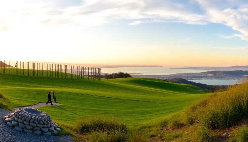
Rising from a former garbage dump on the edge of San Francisco Bay, Byxbee Park is a testament to landscape reclamation and visionary design. Located within the larger Palo Alto Baylands Nature Preserve, this 30-acre site is not a typical green space. Instead, it offers a carefully sculpted topography of rolling hills, a haunting forest of vertical poles, and mounds of oyster shells that honor the area’s natural and cultural history. For hikers, cyclists, birdwatchers, and art enthusiasts, Byxbee Park provides an experience that is at once serene and thought-provoking, all with panoramic views of the bay, the Santa Cruz Mountains, and the East Bay hills.
Park Overview
Byxbee Park is a reclaimed landfill turned public open space, situated at the terminus of Embarcadero Road in Palo Alto, California. It forms the southern gateway to the 1,940-acre Palo Alto Baylands Nature Preserve, one of the largest remaining tracts of undisturbed marshland in the San Francisco Bay Area. The park is named in honor of John Fletcher Byxbee Jr., a visionary city engineer who served Palo Alto from 1906 to 1941 and was instrumental in early efforts to preserve the baylands and develop the city’s infrastructure.
Unlike conventional parks, Byxbee Park is defined by its sculptural landforms and environmental art. The site was a municipal landfill from 1965 until its closure in 1982. After capping the waste with layers of clay and soil, the city commissioned the landscape architecture firm Hargreaves Associates to transform the barren mound into a public space. The result, opened in 1991, is a park that merges ecological function with artistic expression, featuring a series of engineered hills, a grid of wooden poles, and oyster shell mounds that reference the area’s Ohlone heritage and the bay’s ecology.
Location and Map
Byxbee Park is located at 2375 Embarcadero Road, Palo Alto, CA 94303. The main entrance and parking area are at the western end of Embarcadero Road, just past the Palo Alto Baylands Athletic Center and the Lucy Evans Baylands Nature Interpretive Center. The park is part of the larger Baylands Nature Preserve, which stretches along the San Francisco Bay shoreline.
Hours
Byxbee Park is open daily from 8:00 a.m. to sunset. The gates at the Embarcadero Road entrance are locked at sunset, so visitors should plan to return to their vehicles before closing time. The park is open year-round, though some trails may be temporarily closed during heavy rain or for habitat restoration activities.
Size
Byxbee Park encompasses approximately 30 acres of sculpted landforms, trails, and art installations. It is a distinct unit within the much larger Palo Alto Baylands Nature Preserve, which covers 1,940 acres of tidal and freshwater marshes, mudflats, and upland areas.
Amenities
Byxbee Park offers a range of amenities designed to support passive recreation and nature appreciation. The following table summarizes key facilities and their availability.
| Amenity | Availability |
|---|---|
| Parking | Free lot at end of Embarcadero Road (capacity ~50 vehicles) |
| Restrooms | Accessible portable toilets near parking area; permanent restrooms at adjacent Baylands Athletic Center |
| Picnic Areas | Several picnic tables with bay views; no grills |
| Drinking Water | Water fountains available near restrooms |
| Interpretive Signs | Multiple panels explaining ecology, history, and art |
| Benches | Scattered along trails and hilltops |
| Trash Receptacles | Carry-in, carry-out policy; limited bins at entrance |
| Bike Racks | Available at parking lot |
Accessibility
Byxbee Park is designed to be accessible to visitors of all abilities. The main parking lot includes designated accessible spaces. A paved, level pathway leads from the parking area to the primary overlook and the pole field, offering wheelchair users and those with limited mobility the opportunity to experience the park’s signature features. Some of the hilltop trails are unpaved and may be challenging for wheelchairs, but the lower loop and the connection to the Baylands Trail are generally firm and stable. Accessible portable toilets are available on-site. Service animals are welcome, and the park’s interpretive signage is placed at readable heights.
Trails
Byxbee Park is a hub for several interconnected trails that wind through the sculpted hills and link to the broader Baylands trail network. All trails are multi-use, shared by hikers, cyclists, and birdwatchers. The terrain is mostly flat to gently rolling, with some short, steeper climbs to the hilltops.
Byxbee Park Hill Loop
This 0.8-mile loop circles the park’s main sculpted hills, offering 360-degree views of the bay, the pole field, and the surrounding marshes. The surface is a mix of packed gravel and dirt, with a few short inclines. Interpretive signs along the way explain the landfill reclamation process and the park’s design elements.
Pole Field Trail
A flat, 0.3-mile spur leads into the heart of the iconic pole field, where hundreds of vertical wooden poles rise from the ground in a grid pattern. The trail surface is compacted earth and is fully accessible. This area is particularly striking at sunrise and sunset when the poles cast long shadows.
Baylands Trail (Adobe Creek Loop)
Byxbee Park connects directly to the Baylands Trail, a 15-mile network of levees and paths. The Adobe Creek Loop segment passes along the park’s eastern edge, following the creek channel and offering prime birdwatching. This trail is flat, wide, and surfaced with packed gravel, suitable for all users.
Marsh View Trail
A short, 0.2-mile connector leads from the parking area to a viewing platform overlooking the tidal marsh. This trail is paved and fully accessible, with benches for quiet observation.
Natural Features
Despite its engineered origins, Byxbee Park is rich in natural features. The park sits at the transition zone between upland grasslands and tidal salt marshes. The hills are planted with native grasses and wildflowers that attract butterflies and pollinators. The adjacent marshes are part of the San Francisco Bay estuary, one of the most important stopover sites on the Pacific Flyway. Birdlife is abundant: great blue herons, snowy egrets, American avocets, and northern harriers are commonly seen. The mudflats host shorebirds, while the upland areas provide habitat for ground squirrels, jackrabbits, and the occasional gray fox. The park’s design incorporates oyster shell mounds, a nod to the shell middens left by the Ohlone people who inhabited the baylands for thousands of years.
History
The land that is now Byxbee Park was once tidal marsh, part of the vast wetlands that ringed San Francisco Bay. In the early 20th century, portions were diked and used for agriculture and salt production. From 1965 to 1982, the site served as the city of Palo Alto’s municipal landfill, accepting household and construction waste. When the landfill reached capacity, it was capped with a thick layer of clay and soil to prevent leaching and gas migration.
In the late 1980s, the city sought to transform the closed landfill into a public amenity. Landscape architect George Hargreaves of Hargreaves Associates won the design competition with a proposal that embraced the site’s artificiality while reconnecting it to the natural rhythms of the bay. The design included a series of undulating hills that echo the surrounding mountain ranges, a grid of wooden poles that evoke the area’s history as a tidal marsh (the poles reference the remnants of old piers and pilings), and shell mounds that honor the Ohlone’s use of the bay’s resources. The park opened in 1991 and was named for John Fletcher Byxbee Jr., whose foresight in the early 1900s led to the creation of the Palo Alto Baylands and the city’s early sewer and water systems.
Rules and Restrictions
- Hours: Park open 8:00 a.m. to sunset; no entry after dark.
- Dogs: Permitted on leash (6-foot maximum). Owners must clean up after pets.
- Bicycles: Allowed on designated trails; yield to pedestrians.
- Fires and Barbecues: Prohibited. No open flames.
- Camping: Not permitted.
- Drones: Not allowed without a city permit.
- Collecting: Do not remove plants, shells, or artifacts.
- Wildlife: Do not feed or disturb animals.
- Alcohol and Glass Containers: Prohibited.
Transit and Parking
Parking: A free parking lot is located at the end of Embarcadero Road, just past the Baylands Athletic Center. The lot has approximately 50 spaces and can fill on weekends and holidays. Overflow parking is available at the Athletic Center lot when events are not in progress. Accessible parking spaces are provided.
Public Transit: The nearest Caltrain station is California Avenue, approximately 2.5 miles away. From there, VTA Bus Route 88 stops at Embarcadero Road and St. Francis Drive, about 1 mile from the park entrance. The City of Palo Alto’s free Palo Alto Link shuttle service also serves the Baylands area on select routes; check the city website for current schedules. Cycling is a popular option, with dedicated bike lanes along Embarcadero Road leading directly to the park.
Nearby Places
- Lucy Evans Baylands Nature Interpretive Center
- Palo Alto Baylands Athletic Center
- Palo Alto Airport (general aviation)
- Shoreline at Mountain View Park
- Charleston Slough and Mountain View Forebay
- Palo Alto Duck Pond
- Elizabeth F. Gamble Garden
- Stanford University campus
Official Alerts
No active alerts at time of writing. Visitors are advised to check the City of Palo Alto Open Space website for any trail closures due to weather, habitat restoration, or special events. During the rainy season (November–March), some unpaved trails may become muddy and temporarily impassable.
Last Checked
2025-04-10
FAQ
Are dogs allowed in Byxbee Park?
Yes, dogs are welcome but must be kept on a leash no longer than six feet. Owners are required to clean up after their pets.
Is there an entrance fee?
No, Byxbee Park and the entire Baylands Nature Preserve are free to visit.
What are the park hours?
The park is open daily from 8:00 a.m. to sunset. The parking lot gates are locked at sunset.
Can I ride my bicycle in the park?
Yes, bicycles are permitted on designated trails. Riders must yield to pedestrians and follow posted speed limits.
Is the park wheelchair accessible?
Yes, the main pathway to the pole field and overlook is paved and accessible. Accessible portable toilets are available, and designated parking is provided.

Leave a Reply